Sometimes I wonder how I navigated getting myself from one destination to another–BGM (Before Google Maps). Before GIS mapping came ubiquitous on smart phones, I relied on AAA Trip Tickets to show me the travel directions from one state to another. Before AAA Trip Tickets, and in navigational mystery emergencies, a rolled up tattered metro Detroit map is tucked away in the back seat pocket of my car, ready to support me in case technology fails me entirely, forcing me to rely on old technology like a paper map to show me how to get around the city. But if you’ve ever rode in a car with me, sometimes my gut and intuition is the best navigation device to random lostness. Who needs a map, I say? Oh the adventure of the journey!
Helping people find their way is big business. Phone Map apps, in-vehicle navigation systems, portable GPS hand held systems, or heart rate monitors with GPS in them to track your running routes. Digital way finding makes our lives just a bit easier.
Way finding is important to downtowns, too. Way finding signs help drivers and pedestrians figure out where your destination is an the route to get there. Way finding signs point out where to park, where the schools are, where to find historical sites, museums, subways stations, bus stops, where to eat, where to sleep, where to find money, etc. The list is endless how way finding gives you clues about which way to go. We depend on these signs to make it to our destinations relatively calm and happy.
Well, what did people use before phones, maps and way finding signs?
The trees guided the way.
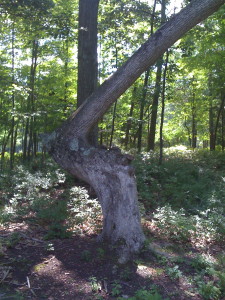
Every summer, we travel to Caseville to chill out and enjoy some Pure Michigan, like the Huron beaches, Kooky Golf and some cycling along the coast line and into the corn fields near the town of Pigeon. Every year on our cycle route, we make our way to a half-built McMansion subdivision, halted midway through construction because of the housing crash. Near the subdivision entry way, tucked away to one side, was one of the few remaining Huron Indian Arrow Trees.
Known as the “direction trees”, the Huron Indian Tribe grew and shaped these trees to provide direction for the tribe as it migrated from The Bay City area to the Port Hope region each summer. In the spring, as the tribe traveled east, they followed the arrow, and in the fall, the followed the direction trees in reverse to return to the Bay City area for the winter.
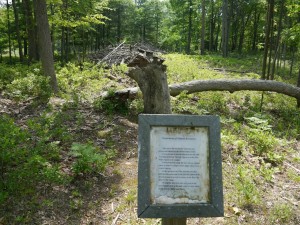
When we rode past this special tree in August 2013, we were sad to learn the tree snapped at its “elbow”.
According to the weathered signed posted by the the DNR, the indians formed the arrow in the tree by tying the tree with the animal sinew to form its unique arrow shape when it was a small sapling. Most of the trees were destroyed by lumber fires and or taken down during logging operations.
Some quick google searches shows these trees were also in Irish Hills, Michigan, or along the I94 route. I don’t know if any of these trees still remain along that part of the state, but I hope they do, hanging on before their trunks give out.
I’m in awe of the Huron Tribe’s ingenuity to design their own natural way finding system using earth’s natural gifts to help guide the way.


Leave a Reply